
By a skipper, for skippers
The logbook that keeps writing while you sail.
LOGisch records position, course, speed and weather in your log on its own, tells from the heel whether you are under sail, and turns the finished trip into a mileage certificate. Offline, no account, no cloud.
- works offline
- PDF & GPX
- for Android
| Time | Position | COG | SOG | Wind | Baro | Power | Remarks |
|---|---|---|---|---|---|---|---|
| 08:40 | 54°25.8′ N 010°10.4′ E | — | — | SW 3 | 1016 | Engine | Start of day, cast off. Engine 1,412.6 h |
| 09:15 | 54°28.1′ N 010°14.9′ E | 045° | 5.2 kn | SW 4 | 1016 | Sail | Sails set |
| 09:52 | 54°30.4′ N 010°17.2′ E | 038° | 6.0 kn | SW 4 | 1015 | Sail | Kiel lighthouse abeam to starboard |
| 10:52 | 54°36.8′ N 010°22.5′ E | 031° | 6.1 kn | WSW 4 | 1015 | Sail | |
| 11:52 | 54°43.0′ N 010°26.9′ E | 029° | 5.7 kn | WSW 5 | 1014 | Sail | First reef |
| 13:40 | 54°51.3′ N 010°31.0′ E | — | — | W 4 | 1014 | Engine | Moored in Marstal. End of day 28.4 nm |
Logs without interrupting you
Entries at a fixed interval, but only while the boat is actually making way. A jumpy GPS at the pontoon or at anchor creates no phantom entries.
Holds up as proof
Automatic entries are marked. Editing after the fact is locked per trip, and unlocking it shows up in the export.
Your log stays on board
No account, no server, no trackers. All data lives on your device, and location is only used while recording.
How it looks
LOGisch on board
Recorded on a trip around Cres, Lošinj and Rab.
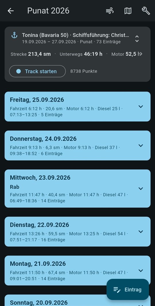
No field is required. Whatever you do not know or cannot measure simply stays empty.
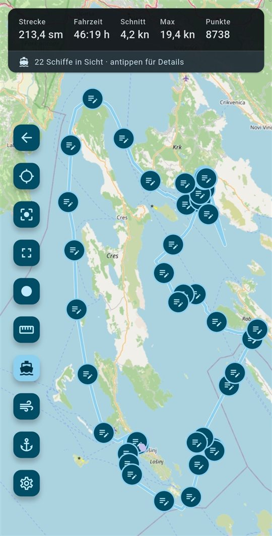
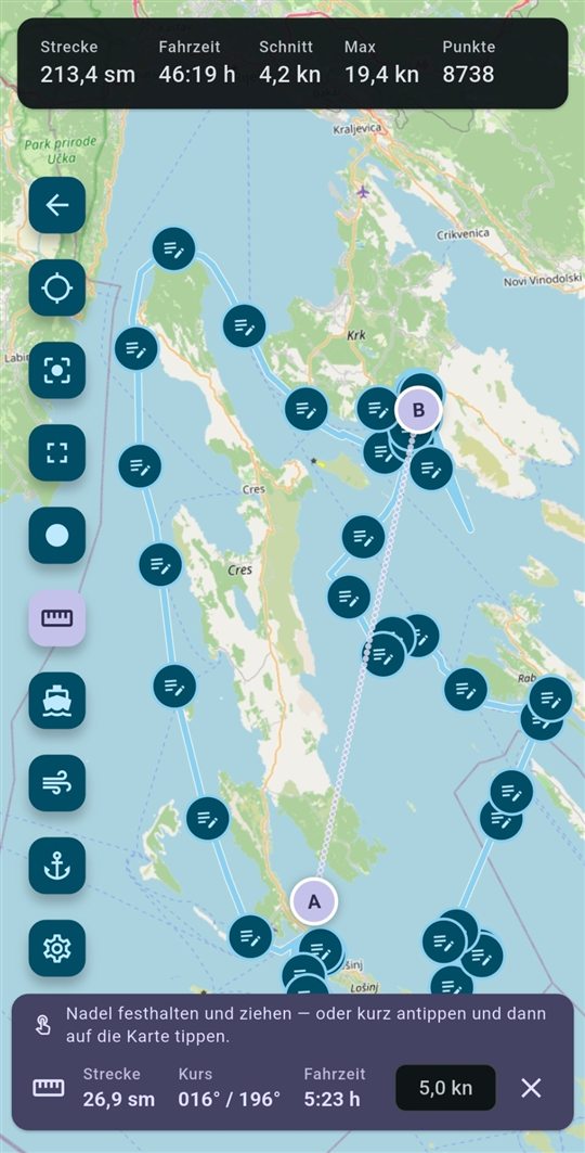
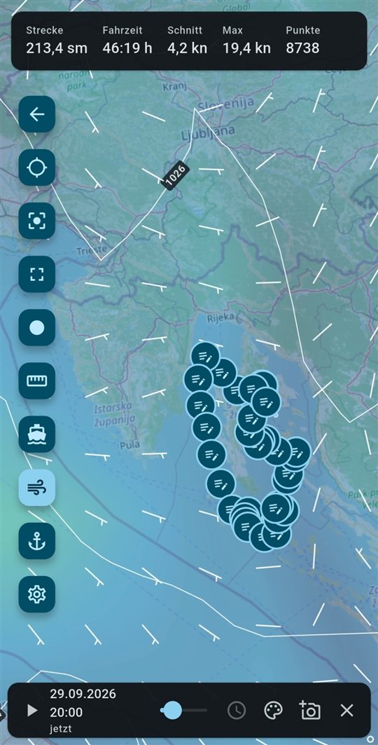
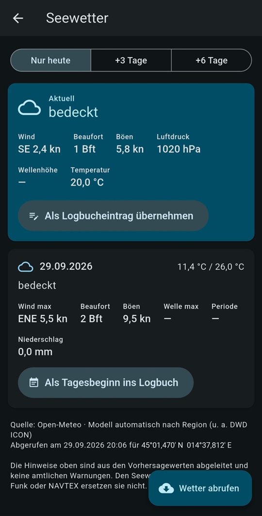
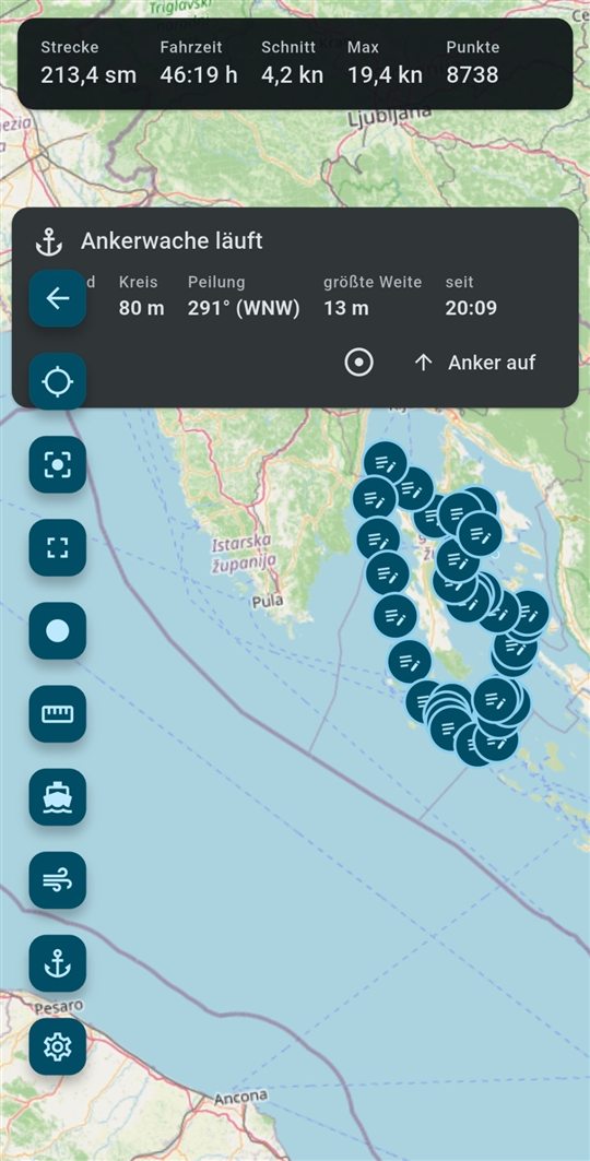
What is recorded at handover. None of it is required — but whatever is here helps later.
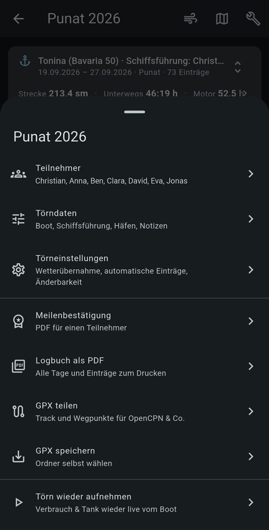
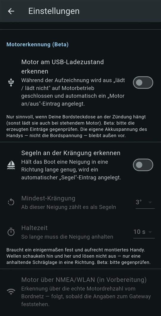
The photographed screens show the German interface. The app follows your phone’s language and can also be switched in the settings.
Features
What LOGisch does on board
Large touch targets for use on deck and with gloves. Everything important works where there is no signal.
Logbook
- Automatic entriesBy time or distance run, with position, course, speed and current weather.
- Sail or engineSustained heel means you are sailing. Waves that just roll the boat do not count. Optionally, LOGisch detects the engine from the charging current or from the engine speed on the boat network (beta).
- Start of trip, start and end of dayThe fixed stages of a trip, with crew, meter readings and tank levels.
- Photos per entryAttach pictures to a log entry without giving the app access to your gallery.
Chart & track
- Chart with seamarksVector chart from OpenFreeMap (data: OpenStreetMap) with the OpenSeaMap seamark layer: buoys, lights, fairways, harbours.
- Clean trackGPS outliers are held back and discarded, real movement keeps its full resolution.
- Dead reckoningBetween two fixes the boat carries on with its last course and speed.
- Measure on the chartDistance and bearing between any points; add more points and it becomes a small route plan with distance, course and time per leg.
Safety
- Anchor watchSet the swing circle; an alarm with sound and vibration goes off when the boat leaves it.
- AIS on the chartNearby vessels with range, bearing, CPA and TCPA.
- Daily checkEngine hours derived from the log, diesel and water consumption at a glance.
- Planned returnDay planning with sunrise, sunset and civil twilight.
Marine weather
- Forecast for your positionWind in Beaufort, gusts, air pressure, weather in plain words – from the Norwegian Meteorological Institute (MET Norway) or, with your own Open-Meteo access, from there (for Europe e.g. with the DWD ICON model).
- Wind field on the chartWind strength as colour, wind direction as flow lines, plus isobars. Wind field and sea state are optional: enter your own Open-Meteo access under “Weather” (subscription or your own server).
- Beaufort alertsDerived from the forecast using common seamanship thresholds. Not a substitute for official warnings.
- Weather in every entryCurrent values go into each new log entry if you want them to.
Boat network (beta)
- Values from the boat networkBoat GPS, heading, log, speed through water, depth, wind and air pressure straight from the instruments (NMEA 0183 over Wi-Fi). Entries and the PDF mark what came from the boat network.
- LOGisch gatewayA small ESP32 on the NMEA 2000 or SeaTalkNG bus brings the data onto Wi-Fi – for Navionics or OpenCPN too. It only listens; nothing goes into the boat network.
- Engine from the RPMLOGisch logs “engine on” and “engine off” from the real engine speed.
- NMEA diagnosisFinds out what the boat sends on its Wi-Fi and creates a report if you like.
Reports
- Logbook as PDFReady to print, with automatic entries marked.
- Mileage certificateSailing days, distances and positions per trip, ready for the skipper’s signature.
- GPX exportTake your track into any navigation or mapping software.
- StatisticsNautical miles, hours under sail and engine, days at sea, nights at anchor and top speed, per trip, per year or overall.
A day with LOGisch
From casting off to dropping anchor
Start of day
Crew, engine hours, tanks. The weather is added automatically.
Cast off
Start recording, put the phone away.
Logging
An entry every hour, sail or engine detected, clean track.
Your own entries
Buoy passed, reef tied in: one tap, position and weather already filled in.
Anchor watch
Set the swing circle in the bay and sleep soundly.
Export
Logbook PDF, mileage certificate and GPX.
Mileage proof
A logbook people can trust
For your next licence, the charter company or your club, documented miles are what count. LOGisch makes sure every entry shows how it came about.
Automatic is markedIn the PDF every automatic entry carries an (A), in the app its own symbol.
Edits leave a traceEditing afterwards is locked per trip. Unlocking works once, cannot be undone and appears in the export.
Closed stays closedWhen a trip ends, boat data such as tank size and consumption are frozen. Later changes to the boat do not alter past trips.
Mileage certificate
- Yacht
- SY “Kielwasser”, 10.4 m
- Trip
- Danish South Sea
- Period
- 14 Jun 2026 – 20 Jun 2026
- Role
- Crew
| Day | From → To | nm | Time |
|---|---|---|---|
| 14 Jun | Kiel-Schilksee → Marstal | 28.4 | 5:00 |
| 15 Jun | Marstal → Svendborg | 22.1 | 4:25 |
| 16 Jun | Svendborg → Lyø | 19.7 | 3:50 |
| 18 Jun | Lyø → Sønderborg | 26.3 | 5:15 |
| 20 Jun | Sønderborg → Kiel-Schilksee | 31.8 | 6:05 |
| 5 sailing days | 128.3 | 24:35 | |
Calculated from track and log. Sample data.
Privacy
No account, no cloud, no profile
LOGisch only goes online when the chart, weather or AIS need it. All it sends is the chart area you are looking at. Full details
On your device
Log, track, photos and settings only leave your phone when you export them yourself.
Location on your terms
Only while a recording you started is running. A notification shows that it is active.
Charts & weather
Tiles and forecasts from open sources, without any identifier.
OpenFreeMap / OpenStreetMap · OpenSeaMap · MET Norway
AIS is optional
Only with your own key, stored encrypted in the Android Keystore.
aisstream.io
Download
LOGisch for Android
LOGisch is coming soon for Android. If you’d like to hear when it launches, send me a short e-mail.
- SystemAndroid 7.0 or later
- Boat networkoptional: LOGisch gateway or another device sending NMEA 0183 over Wi-Fi
- App languageEnglish, German
- Version1.0.0
Contact
Questions, bugs, ideas
Just send me an email. Feedback from on board is the best kind, ideally with a screenshot and your Android version. German or English, both are fine.